| BOUNDARY LINE BETWEEN EASTERN AND CENTRAL ZONES. | |
|---|---|
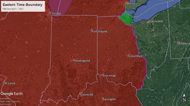 Effective April 1, 1922 - March 30, 1924 66 I.C.C. 566 - Decided March 13, 1922 - Effective April 1, 1922 Michigan-Ohio. -- Beginning on the boundary line between the United States and Canada east of Port Huron, Mich.; thence southerly and easterly along the international boundary line through the St Clair River, Lake St. Clair, Detroit River, and Lake Erie to the intersection of the International boundary line with the boundary line between the states of Ohio and Michigan; thence westerly and southerly along the north line of Ohio to the Ottawa River; thence southwesterly along the thread of the Ottawa River to the Toledo Terminal Railroad; thence westerly, southerly, easterly, and northerly immediately and respectively south, east, north, and west of and parallel with the Toledo Terminal Railroad to its intersection with the New York Central Railroad at Vickers; thence easterly and southerly immediately south and west of and parallel with the New York Central Railroad to Monroevllle, crossing in said course the Lake Erie & Western Railroad at Fremont, the Cleveland, Cincinnati, Chicago & St. Louis Railway at Clyde, the New York, Chicago & St. Louis Railroad, and the line of the Pennsylvania Company at Bellevue; thence southerly immediately west of and parallel with the Baltimore & Ohio Railroad to the northern boundary line of Perry county, near Bruno, crossing in said course the Baltimore & Ohio Railroad at Willard, the Northern Ohio Railway at Plymouth, the Cleveland, Cincinnati, Chicago & St. Louis Railway at Shelby Junction, the Chicago division of the Pennsylvania Company, and the Erie Railroad at Mansfield, the lines of the Pennsylvania Company at Mount Vernon and Newark, and the line of the Baltimore & Ohio at Newark; thence easterly and southerly along the boundary line between Perry county and Licking and Muskingum counties to the northwest corner of Morgan county, crossing in said course the Baltimore & Ohio Railroad near Bruno, the Zanesvllle & Western Railway near Fultonham and East Fultonham, and the Zanesvllle division of the Pennsylvania Company at Roseville; thence easterly along the northern boundary line of Morgan county to the Meridian 82° west; thence south along said meridian to the Ohio River, crossing in said course the Federal Valley Railroad at Lewis and the Baltimore & Ohio Railroad at Canaanvllle; thence following the Ohio River along the line between Ohio and West Virginia southerly and westerly to the junction of the states of Ohio, West Virginia, and Kentucky. Effective August 27, 1922 the boundary was changed to add the City of Detroit to Eastern Time. At the time Michigan state law specified Central Time and Detroit city law specified Eastern Time. 73 I.C.C. 78 - Decided July 25, 1922 - Effective August 27, 1922 Michigan. -- Beginning on the boundary line between the United States and Canada east of Port Huron, Mich.; thence southerly along the International boundary line through the St. Clair River and Lake St. Clair to its intersection with the easterly boundary of the city of Detroit; thence northwesterly, westerly, southerly, and easterly, along the boundary of the city of Detroit to its intersection with the international boundary in the Detroit River; thence southerly along the international boundary line in the Detroit River and Lake Erie to its Intersection with the boundary line between the States of Ohio and Michigan. 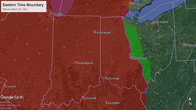 Effective March 30, 1924 - August 31, 1924 88 I.C.C. 135 - Decided March. 13, 1924 - Effective March 30, 1924 Ohio. -- From the intersection of the international boundary between the United States and Canada with the boundary between the States of Ohio and Michigan thence westerly and southerly along the north line of Ohio to the Ottawa River; thence southwesterly along the thread of the Ottawa River to the Toledo Terminal Railroad; thence westerly, southerly, and easterly immediately and respectively south, east, and north of and parallel with the Toledo Terminal Railroad to its intersection with the eastern division of the Ohio Central lines of the New York Central Railroad west of Walbridge; thence southerly immediately west of and parallel with the said eastern division of the Ohio Central lines to its intersection with the Hocking Valley Railway at Fostoria; thence southerly immediately west of and parallel with the Hocking Valley Railway to its intersection with the boundary of the city of Columbus, crossing in said course the lines of the New York, Chicago & St. Louis Railroad and the line of the Baltimore & Ohio Railroad at Fostoria, the Northern Ohio Railway and the Cleveland, Cincinnati, Chicago & St. Louis Railway at Carey, the Pennsylvania Railroad at Upper Sandusky, the Erie Railroad at Marlon, and the lines of the Cleveland, Cincinnati, Chicago & St. Louis Railway at Marion and at Delaware; thence westerly, southerly, and easterly along the boundary of the city of Columbus to Its intersection with the Hocking Valley Railway at South Columbus; thence southerly and easterly immediately west and south of and parallel with the Hocking Valley Railway to the Ohio River at Gallipolis, crossing in said course the Norfolk & Western Railway at Valley Crossing, the Pennsylvania Railroad at Lancaster, and the Baltimore & Ohio Railroad and a branch of the Hocking Valley Railway at Dundas; thence following the Ohio River along the boundary between Ohio and West Virginia to its intersection with the east line of Wayne County, W. Va. West Virginia. -- From the intersection of the boundary between Ohio and West Virginia with the east line of Wayne County southerly along the said east line of Wayne County to its intersection with the Norfolk & Western Railway near Wilsondale; thence southerly, westerly, and southerly immediately and respectively east, south, and east of and parallel with the Norfolk & Western Railway to Williamson; thence southerly immediately west of and parallel with the Pond Creek branch of the Norfolk & Western Railway to the boundary between the States of West Virginia and Kentucky; thence southerly along the boundary between West Virginia and Kentucky to its intersection with the line between Kentucky and Virginia. 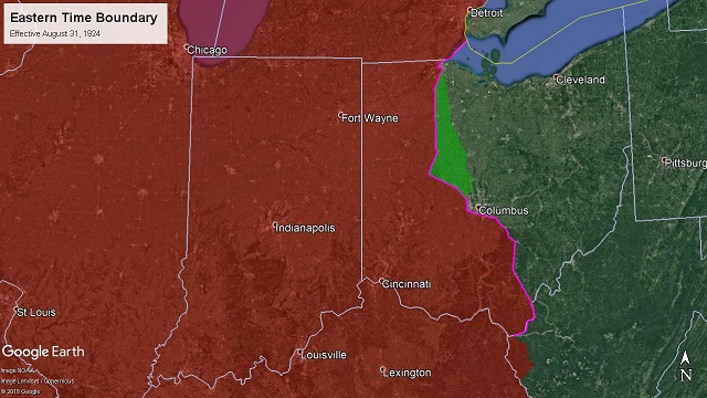 Effective August 31, 1924 - April 3, 1927 91 I.C.C. 686 - Decided July 23, 1924 - Effective August 31, 1924 Ohio. -- From the intersection of the international boundary between the United States and Canada with the boundary between the States of Ohio and Michigan; thence westerly and southerly along the north line of Ohio to the Ottawa River ; thence southwesterly along the thread of the Ottawa River to the Toledo Terminal Railroad; thence westerly, southerly, and easterly immediately and respectively south, east, and north of and parallel with the Toledo Terminal Railroad to its intersection with the western division of the Ohio Central lines of the New York Central Railroad west of Walbridge; thence southerly immediately west of and parallel with the said western division of the Ohio Central lines to its intersection with the Cleveland, Cincinnati, Chicago & St. Louis Railway at Kenton, crossing in said course the lines of the Baltimore & Ohio Railroad at Galatea, the New York, Chicago & St. Louis Railroad at Mortimer, the line of the Lake Erie & Western at Findlay, the line of the Northern Ohio Railway at Arlington, and the line of the Pennsylvania Railroad at Dunkirk; thence southerly Immediately west of and parallel with the Cleveland, Cincinnati, Chicago & St. Louis Railway to its intersection with the St. Mary's branch of the Ohio Central lines at Bellefontaine, crossing in said course the line of the Erie Railroad at Kenton; thence easterly and southerly immediately south and west of and parallel with the line of the Ohio Central Railroad from Bellefontaine to Columbus, crossing in said course the line of the Erie Railroad at Peoria and the line of the Cleveland, Cincinnati, Chicago & St. Louis Railway at Marysville; thence westerly, southerly, and easterly along the boundary of the city of Columbus to its intersection with the Hocking Valley Railway at South Columbus; thence southerly and easterly Immediately west and south of and parallel with the Hocking Valley Railway to the Ohio River at Gallipolls, crossing in said course the Norfolk & Western Railway at Valley Crossing, the Pennsylvania Railroad at Lancaster, and the Baltimore & Ohio Railroad and a branch of the Hocking Valley Railway at Dundas; thence following the Ohio River along the boundary between Ohio and West Virginia to its intersection with the east line of Wayne County, W. Va. 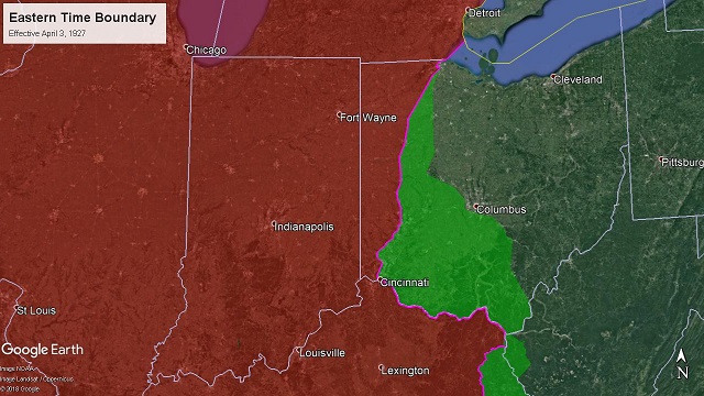 Effective April 3, 1927 - September 27, 1936 122 I.C.C. 122 - Decided January 11, 1927 - Effective April 3, 1927 Ohio. -- From the intersection of the international boundary between the United States and Canada with the boundary between the States of Ohio and Michigan; thence westerly and southerly along the north line of Ohio to Ottawa River; thence southwesterly along the thread of the Ottawa River to the Toledo Terminal Railroad ; thence westerly, southerly, and easterly, immediately and respectively south, east, and north of and parallel with the Toledo Terminal Railroad to its intersection with the Toledo division of the Baltimore & Ohio Railroad at Bates, Ohio; thence southerly immediately west and parallel with the said Toledo division of the Baltimore & Ohio Railroad to Cincinnati, crossing in said course the line of the Baltimore & Ohio Railroad at Deshler, the New York, Chicago & St. Louis Railway at Leipsic Junction, the line of the Northern Ohio Railway at Columbus Grove, the Detroit, Toledo & Ironton Railroad at Leipsic, the lines of the Pennsylvania Railroad, New York, Chicago & St. Louis, and Erie Railroad at Lima, the line of the Ohio Central lines of the New York Central Railroad at Wapakoneta, the line of the Big Four at Sidney, the line of the Pennsylvania Railroad at Piqua, the line of the Big Four at Troy, Ohio, the line of the Pennsylvania at Dayton, the line of the Cincinnati Northern at Carlisle, and the lines of the Cincinnati, Indianapolis & Western and the Pennsylvania at Hamilton; thence following the western boundary line of the city of Cincinnati to the Ohio River, crossing in said route, the lines of the Chesapeake & Ohio Railway of Indiana, Big Four, and Baltimore & Ohio Railroad, thence crossing the Ohio River to Covington, Ky., thence southeasterly immediately south of and parallel with the Chesapeake & Ohio Railway to Catlettsburg, Ky., and the intersection with the boundary line between Kentucky and West Virginia, crossing in said course the Chesapeake & Ohio Railway at Ashland, Ky. Kentucky-West Virginia. -- From Catlettsburg south immediately west of and parallel with the Big Sandy division of the Chesapeake & Ohio Railroad to the northern boundary of Lawrence County, Kentucky, thence westerly and southerly along the west lines of Lawrence, Johnson, Floyd, and south line of Pike Counties to the boundary line between Kentucky and Virginia, thence north easterly along the boundary line between Kentucky and Virginia to the west line of Dickenson County, Va. | |
| < 1919 | 1936-1960 > |